The Noosa River
Home > Visiting Kinaba > The Noosa River
The Noosa River: Heart of Cooloola
Flowing from the Como Scarp through the diverse landscapes of Cooloola to the sea at Laguna Bay, the Noosa River is one of Queensland’s most remarkable natural waterways. Meandering through forests, wetlands, lakes and expansive plains, the river forms a unique ecosystem renowned for its beauty, biodiversity and tranquillity.
A river of three distinct landscapes
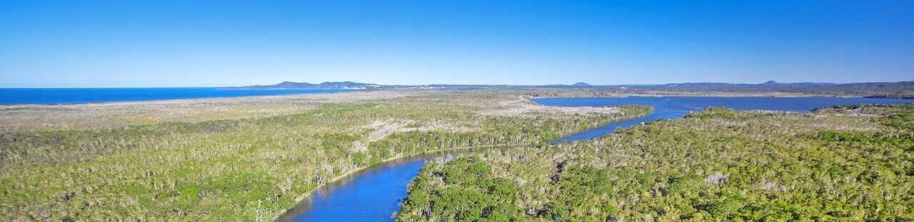
The Noosa River unfolds in three distinct sections:
- Lower Tidal Estuary – extending from the river mouth near Noosa Heads through Noosaville and Tewantin to Lake Cootharaba, where tidal influence gradually fades.
- Middle Reaches and Everglades – a serene network of tea-tree-lined waterways, shallow lakes and mirrored blackwater channels often compared to the Florida Everglades.
- Upper Reaches – quieter freshwater streams winding westward through Wallum country toward the Como Scarp.
This slow-moving river system includes Lakes Cooroibah, Cootharaba and Figtree Lake, connected by wetlands and melaleuca forests that support an extraordinary diversity of wildlife.
Geological origins
The river’s unique character is shaped by ancient geological history. Scientists believe the Noosa River and surrounding plains were once part of the Great Sandy Strait, linking Tin Can Bay to the ocean at Noosa Heads. Over time, volcanic uplift and changing sea levels transformed the landscape into the river and lake system seen today.
The vast Noosa Plain and shallow lakes remain evidence of this ancient marine environment, while the surrounding sand mass acts like a giant natural reservoir, slowly filtering water through peat swamps into the river.
The magic of blackwater
One of the river’s defining features is its striking dark water. Naturally stained by organic material from peat and vegetation, the water takes on a rich tea-coloured hue that becomes mirror-black in deeper sections. On calm days, the river perfectly reflects the surrounding melaleucas and wildlife, creating the magical stillness for which the Noosa Everglades are famous.
Despite its colour, the water is exceptionally pure and low in pollutants. The perched dune lakes hidden within the Cooloola sandmass contain some of the cleanest freshwater in Australia.
Lakes, wetlands and wildlife
Lake Cootharaba and the surrounding tidal wetlands are ecologically significant habitats supporting mangroves, seagrass beds, fish nurseries and abundant birdlife. The estuary contains one of the largest concentrations of seagrass south of Bowen, providing vital habitat for marine species.
The shallow lakes attract pelicans and waterbirds, while mangrove forests thrive surprisingly far inland due to the estuary’s subtle tidal influence.
The Noosa Everglades
The upper reaches of Lake Cootharaba and Fig Tree Lake are locally known as the “Everglades” — a spectacular wilderness of narrow waterways, paperbark forests and untouched wetlands. Accessible mainly by canoe or silent craft, this region offers one of Australia’s most peaceful nature experiences.
To protect the fragile banks and ecosystems, strict low-speed boating limits apply throughout much of the river system.
Womalah Wallum: The western catchment
West of the river lies the softer, rolling landscape of the Womalah Wallum — a mosaic of open forests, heathlands and wetlands rich in native flora. Scribbly gums, banksias, bloodwoods and paperbarks dominate the landscape, creating spectacular seasonal displays of blossom and wildflowers.
The area is also biologically significant, containing rare plant species and diverse habitats that have become the focus of extensive environmental research and conservation efforts.
A landscape worth protecting
The Noosa River and Cooloola region remain one of Queensland’s most treasured natural environments. From pristine dune lakes and mirrored blackwater channels to mangrove estuaries and ancient forests, the region represents an extraordinary blend of geological history, ecological richness and cultural significance that continues to inspire visitors and conservationists alike.
Check out our Gateway to Kinaba photo gallery.
Reference: Discovering Cooloola – a complete guide & map
by John Sinclair 1978
National Library of Australia ↗️